Issue
Growing interest in the oceans and coasts has led to increased demand for geospatial data. Ocean and coastal maps and charts are used for many activities, including navigation, ocean exploration, coastal and living resource management, hazards preparedness, response and mitigation, and habitat assessments. Mapping data is also used in many ocean and coastal modeling efforts. As multiple agencies and offices attempt to keep up with the rapidly-growing demand for this geospatial data, there is increased risk of duplication of effort in data acquisition, tool development, and data delivery mechanisms.
Process
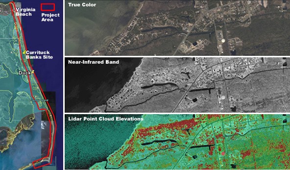
NOAA's Integrated Ocean and Coastal Mapping (IOCM) effort was initiated to combine and coordinate NOAA's coastal and ocean mapping activities and disseminate data. Project partners engaged in joint discussions regarding project areas, goals, and objectives prior to data acquisition. High-resolution aerial imagery and topographic lidar were acquired by NOAA’s National Geodetic Survey during one of the first NOAA IOCM pilot projects, which covered approximately 1500 kilometers squared extending from Cape Hatteras to Virginia Beach and encompassed the Currituck Banks National Estuarine Research Reserve (NERR).
Impact
The partners’ ability to engage in joint discussions prior to data acquisition has increased efficiency, eliminated duplication, and increased the use of important data sets. Data acquired through the first pilot project are being used for nautical charting applications and to help the Currituck Banks NERR site monitor changes in bathymetry, seasonal conditions of hydrology, subtidal habitats, and broad-scale changes in land cover. The NOAA Office for Coastal Management and NOAA Estuarine Reserve Division are assisting the Currituck Banks Reserve with an invasive species application, delineating Phragmites australis stands from the imagery and elevation data. These data sets are also being used by NOAA’s National Geodetic Survey in research studies to assess the accuracy of lidar-derived mean high water shoreline.

Additional Information
Contributors
- Currituck Banks Component of North Carolina National Estuarine Research Reserve
- Federal Emergency Management Agency
- North Carolina Division of Transportation
- North Carolina Division of Emergency Management
- NOAA Center for Operational Oceanographic Products and Services
- NOAA National Centers for Coastal Ocean Science
- NOAA National Geodetic Survey
- NOAA Office of Coast Survey
- NOAA Office for Coastal Management
- U.S. Army Corps of Engineers
